


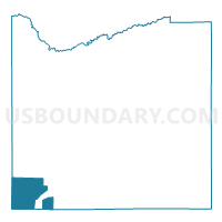
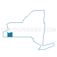
Voting District 330001, Cattaraugus County, New York
About
Outline

Summary
| Unique Area Identifier | 625678 |
| Name | Voting District 330001 |
| County | Cattaraugus County |
| State | New York |
| Area (square miles) | 37.09 |
| Land Area (square miles) | 36.84 |
| Water Area (square miles) | 0.25 |
| % of Land Area | 99.33 |
| % of Water Area | 0.67 |
| Latitude of the Internal Point | 42.04526000 |
| Longtitude of the Internal Point | -79.00270900 |
Maps

Graphs
Select a template below for downloading or customizing gragh for Voting District 330001, Cattaraugus County, New York


Neighbors
Neighoring Voting District (by Name) Neighboring Voting District on the Map
- Voting District 030001, Chautauqua County, NY
- Voting District 030002, Chautauqua County, NY
- Voting District 030003, Chautauqua County, NY
- Voting District 040001, Cattaraugus County, NY
- Voting District 210002, Chautauqua County, NY
- Voting District 290002, Cattaraugus County, NY
- Voting District 350000, Cattaraugus County, NY
- CORYDON TWP Voting District, McKean County, PA
- ELK TWP Voting District, Warren County, PA
- MEAD TWP Voting District, Warren County, PA
- PINE GROVE TWP Voting District, Warren County, PA
Top 10 Neighboring County Subdivision (by Population) Neighboring County Subdivision on the Map
- Carroll town, Chautauqua County, NY (3,524)
- Pine Grove township, Warren County, PA (2,695)
- Randolph town, Cattaraugus County, NY (2,602)
- Poland town, Chautauqua County, NY (2,356)
- Mead township, Warren County, PA (1,386)
- Allegany Reservation, Cattaraugus County, NY (1,020)
- Coldspring town, Cattaraugus County, NY (663)
- Elk township, Warren County, PA (520)
- Corydon township, McKean County, PA (275)
- South Valley town, Cattaraugus County, NY (264)
Top 10 Neighboring Unified School District (by Population) Neighboring Unified School District on the Map
- Warren County School District, PA (38,402)
- Bradford Area School District, PA (21,133)
- Randolph Central School District, NY (6,597)
- Frewsburg Central School District, NY (4,904)
Top 10 Neighboring State Legislative District Lower Chamber (by Population) Neighboring State Legislative District Lower Chamber on the Map
- Assembly District 149, NY (121,064)
- State House District 65, PA (59,457)
- State House District 67, PA (56,066)
Top 10 Neighboring State Legislative District Upper Chamber (by Population) Neighboring State Legislative District Upper Chamber on the Map
- State Senate District 57, NY (285,036)
- State Senate District 21, PA (235,571)
- State Senate District 25, PA (233,497)
Top 10 Neighboring 111th Congressional District (by Population) Neighboring 111th Congressional District on the Map
- Congressional District 29, NY (663,727)
- Congressional District 5, PA (651,762)
- Congressional District 3, PA (640,356)
- Congressional District 27, NY (629,271)
Top 10 Neighboring Census Tract (by Population) Neighboring Census Tract on the Map
- Census Tract 9403, Cattaraugus County, NY (6,490)
- Census Tract 9613, Cattaraugus County, NY (5,287)
- Census Tract 9614, Cattaraugus County, NY (5,189)
- Census Tract 375, Chautauqua County, NY (4,874)
- Census Tract 374, Chautauqua County, NY (3,999)
- Census Tract 9702, Warren County, PA (3,954)
- Census Tract 4201, McKean County, PA (3,415)
- Census Tract 9701, Warren County, PA (2,356)
Top 10 Neighboring 5-Digit ZIP Code Tabulation Area (by Population) Neighboring 5-Digit ZIP Code Tabulation Area on the Map
- 16701, PA (17,980)
- 14779, NY (6,932)
- 14772, NY (4,255)
- 14738, NY (3,651)
- 16345, PA (3,543)
- 14747, NY (2,289)
- 14783, NY (320)